Geolocate

Les Granges topographic map

Click on the map to display elevation.

About this map

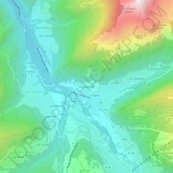
Name: Les Granges topographic map, elevation, terrain.

Location: Les Granges, Montriond, Thonon-les-Bains, Haute-Savoie, Auvergne-Rhône-Alpes, France métropolitaine, 74110, France (46.18285 6.66806 46.22285 6.70806)

Average elevation: 1,164 m

Minimum elevation: 822 m

Maximum elevation: 2,111 m

Other topographic maps

Click on a map to view its topography, its elevation and its terrain.

Gear up for your next adventure:

👟Sport Hiking Sandals - Breathable footwear for water crossings and camp rest
🧭GPS Tracker - Track your location in remote areas safely
Backpacking Tent - Lightweight tent for long-distance hiking trips
🕶️Polarized Sunglasses - Reduces glare from snow and water at high elevations
🧰Emergency Multi-Tool - Compact multi-tool for outdoor survival

As an Amazon Associate, this site earns from qualifying purchases at no extra cost to you.