
Le Chevain topographic map
Interactive map
Click on the map to display elevation.
About this map
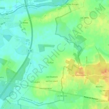
Name: Le Chevain topographic map, elevation, terrain.
Average elevation: 143 m
Minimum elevation: 128 m
Maximum elevation: 168 m
Other topographic maps
Click on a map to view its topography, its elevation and its terrain.
Saint-Paterne
France > Pays de la Loire > Sarthe > Saint-Paterne - Le Chevain
Saint-Paterne, Saint-Paterne - Le Chevain, Mamers, Sarthe, Pays de la Loire, France métropolitaine, 72610, France
Average elevation: 138 m