
Shannon Municipal District topographic map
Interactive map
Click on the map to display elevation.
About this map
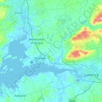
Name: Shannon Municipal District topographic map, elevation, terrain.
Location: Shannon Municipal District, Comté de Clare, Munster, Irlande (52.66153 -8.99690 52.80161 -8.50165)
Average elevation: 35 m
Minimum elevation: -26 m
Maximum elevation: 418 m
Other topographic maps
Click on a map to view its topography, its elevation and its terrain.
Spanish Point
Spanish Point, Milltown Malbay ED, West Clare Municipal District, Comté de Clare, Munster, V95 R883, Irlande
Average elevation: 10 m
Shannon
Shannon, Shannon Municipal District, Comté de Clare, Munster, Irlande
Average elevation: 6 m
Kilfenora
Kilfenora, Kilfenora ED, West Clare Municipal District, Comté de Clare, Munster, Irlande
Average elevation: 70 m
West Clare Municipal District
West Clare Municipal District, Comté de Clare, Munster, Irlande
Average elevation: 37 m
Clare Commons
Clare Commons, Clareabbey ED, Ennis Municipal District, Comté de Clare, Munster, Irlande
Average elevation: 6 m
Creggaunnahilla
Creggaunnahilla, Primrose Gardens, Clareabbey ED, Ennis Municipal District, Comté de Clare, Munster, Irlande
Average elevation: 7 m