
Daumeray topographic map
Interactive map
Click on the map to display elevation.
About this map
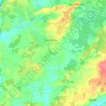
Name: Daumeray topographic map, elevation, terrain.
Average elevation: 42 m
Minimum elevation: 19 m
Maximum elevation: 91 m
Other topographic maps
Click on a map to view its topography, its elevation and its terrain.
Morannes
France > Pays de la Loire > Maine-et-Loire > Morannes sur Sarthe-Daumeray
Morannes, Morannes sur Sarthe-Daumeray, Angers, Maine-et-Loire, Pays de la Loire, France métropolitaine, 49640, France
Average elevation: 36 m