Geolocate

Mall topographic map

Click on the map to display elevation.

About this map

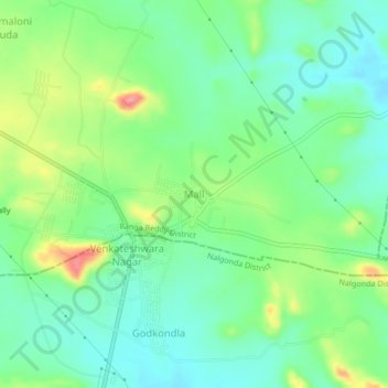
Name: Mall topographic map, elevation, terrain.

Location: Mall, Yacharam mandal, Ranga Reddy District, Telangana, India (16.95782 78.71678 16.99782 78.75678)

Average elevation: 513 m

Minimum elevation: 482 m

Maximum elevation: 577 m

Gear up for your next adventure:

🧥Waterproof Hiking Jacket - Protect yourself from rain and wind while hiking
🧴First Aid Kit - Essential first aid supplies for outdoor emergencies
🧥Insulated Jacket - Keep warm in cold outdoor conditions
🔭Outdoor Binoculars - Lightweight binoculars for birdwatching and hiking
🧥Softshell Jacket - Windproof and breathable jacket for hiking

As an Amazon Associate, this site earns from qualifying purchases at no extra cost to you.