Geolocate

Raivavae topographic map

Click on the map to display elevation.

Raivavae

Raivavae (Tahitian: Ra‘ivāvae /ra.ʔi.va:va.e/) is one of the Austral Islands in French Polynesia. Its total land area including offshore islets is 17.9 km2 (6.9 sq mi). At the 2017 census, it had a population of 903. The island is of volcanic origin, and rises to 437 metres (1,434 ft) elevation at Mont Hiro.

Wikipedia (CC-BY-SA 3.0)

About this map

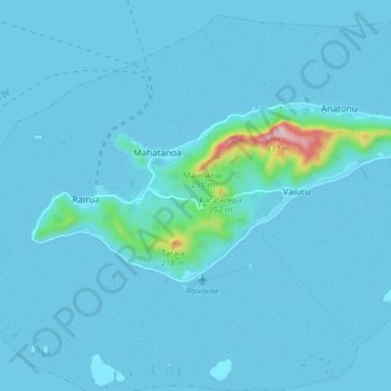
Name: Raivavae topographic map, elevation, terrain.

Location: Raivavae, Austral Islands, French Polynesia, 98750, France (-23.88779 -147.70066 -23.85181 -147.61893)

Average elevation: 19 m

Minimum elevation: -1 m

Maximum elevation: 394 m

Gear up for your next adventure:

🧭GPS Outdoor Watch - Smart watch for navigation and fitness tracking in nature
🌬️Windproof Camp Stove - Efficient cooking even on exposed mountain peaks
🧥Softshell Jacket - Windproof and breathable jacket for hiking
🧶550 Survival Paracord - Versatile utility cord for emergency repairs and rigging
🧰Multitool Knife - Compact and versatile tool for outdoor use

As an Amazon Associate, this site earns from qualifying purchases at no extra cost to you.