
Make a donation
Gear up for your next adventure:
As an Amazon Associate, this site earns from qualifying purchases at no extra cost to you.
Untersiemau topographic map
Click on the map to display elevation.
Make a donation
Gear up for your next adventure:
As an Amazon Associate, this site earns from qualifying purchases at no extra cost to you.
Untersiemau
Untersiemau liegt am Ostrand des Itzgrunds etwa zehn Kilometer südlich von Coburg auf einer Höhe von etwa 300 Metern. Östlich des Ortes erstreckt sich der Lichtenfelser Forst.
Make a donation
Gear up for your next adventure:
As an Amazon Associate, this site earns from qualifying purchases at no extra cost to you.
About this map
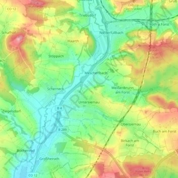
Name: Untersiemau topographic map, elevation, terrain.
Location: Untersiemau, Landkreis Coburg, Bayern, 96253, Deutschland (50.17322 10.91416 50.22707 11.01104)
Average elevation: 319 m
Minimum elevation: 264 m
Maximum elevation: 405 m
Make a donation
Gear up for your next adventure:
As an Amazon Associate, this site earns from qualifying purchases at no extra cost to you.