
Make a donation
Gear up for your next adventure:
As an Amazon Associate, this site earns from qualifying purchases at no extra cost to you.
Provence-Alpes-Côte d'Azur topographic map
Click on the map to display elevation.
Make a donation
Gear up for your next adventure:
As an Amazon Associate, this site earns from qualifying purchases at no extra cost to you.
About this map
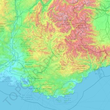
Name: Provence-Alpes-Côte d'Azur topographic map, elevation, terrain.
Location: Provence-Alpes-Côte d'Azur, Metropolitan France, France (42.98201 4.23014 45.12660 7.71848)
Average elevation: 665 m
Minimum elevation: -3 m
Maximum elevation: 3,946 m
Make a donation
Gear up for your next adventure:
As an Amazon Associate, this site earns from qualifying purchases at no extra cost to you.
Other topographic maps
Click on a map to view its topography, its elevation and its terrain.
Grison
France > Pays de la Loire > Loire-Atlantique > Vallons-de-l'Erdre > Saint-Mars-la-Jaille
Average elevation: 49 m
Make a donation
Gear up for your next adventure:
As an Amazon Associate, this site earns from qualifying purchases at no extra cost to you.