Geolocate

Mocoa topographic map

Click on the map to display elevation.

About this map

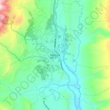
Name: Mocoa topographic map, elevation, terrain.

Location: Mocoa, Putumayo, Amazonia, 860001, Colombia (1.10663 -76.68823 1.18663 -76.60823)

Average elevation: 752 m

Minimum elevation: 503 m

Maximum elevation: 1,494 m

Other topographic maps

Click on a map to view its topography, its elevation and its terrain.

Vereda Los Andes

Colombia > Putumayo > Mocoa

Average elevation: 839 m

Vereda San Antonio

Colombia > Putumayo > Mocoa

Average elevation: 1,063 m

Vereda Medio Afán

Colombia > Putumayo > Mocoa

Average elevation: 737 m

Vereda Las Planadas

Colombia > Putumayo > Mocoa

Average elevation: 636 m

Vereda La Florida

Colombia > Putumayo > Mocoa

Average elevation: 993 m

Zona Urbana

Colombia > Putumayo > Mocoa

Average elevation: 667 m

Gear up for your next adventure:

🌡️Emergency Mylar Blankets - Compact thermal protection for unexpected nights outdoors
🚲Handlebar Phone Mount - View topographic-map.com live while cycling
🥾Light Trekking Boots - Supportive boots for multi-day treks
🛶Waterproof Dry Bags - Keep electronics and clothes dry during river crossings
🥾Trail Hiking Shoes - Durable shoes designed for rugged trails

As an Amazon Associate, this site earns from qualifying purchases at no extra cost to you.