
Make a donation
Gear up for your next adventure:
As an Amazon Associate, this site earns from qualifying purchases at no extra cost to you.
Bonnenuit topographic map
Click on the map to display elevation.
Make a donation
Gear up for your next adventure:
As an Amazon Associate, this site earns from qualifying purchases at no extra cost to you.
About this map
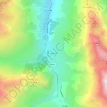
Name: Bonnenuit topographic map, elevation, terrain.
Average elevation: 2,092 m
Minimum elevation: 1,574 m
Maximum elevation: 2,871 m
Make a donation
Gear up for your next adventure:
As an Amazon Associate, this site earns from qualifying purchases at no extra cost to you.
Other topographic maps
Click on a map to view its topography, its elevation and its terrain.
Refuge des Aiguilles d'Arves
France > Auvergne-Rhône-Alpes > Savoie > Valloire
Average elevation: 2,500 m
Combe de Beaujournal
France > Auvergne-Rhône-Alpes > Savoie > Valloire > Les Choseaux-Verneys
Average elevation: 2,012 m
Make a donation
Gear up for your next adventure:
As an Amazon Associate, this site earns from qualifying purchases at no extra cost to you.