
Make a donation
Gear up for your next adventure:
As an Amazon Associate, this site earns from qualifying purchases at no extra cost to you.
Bras Madeleine topographic map
Click on the map to display elevation.
Make a donation
Gear up for your next adventure:
As an Amazon Associate, this site earns from qualifying purchases at no extra cost to you.
About this map
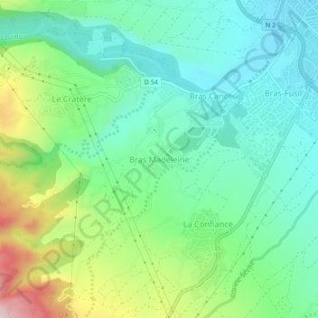
Name: Bras Madeleine topographic map, elevation, terrain.
Location: Bras Madeleine, Saint-Benoît, La Réunion, 97437, France (-21.07731 55.67676 -21.03731 55.71676)
Average elevation: 130 m
Minimum elevation: 9 m
Maximum elevation: 422 m
Make a donation
Gear up for your next adventure:
As an Amazon Associate, this site earns from qualifying purchases at no extra cost to you.
Other topographic maps
Click on a map to view its topography, its elevation and its terrain.
Make a donation
Gear up for your next adventure:
As an Amazon Associate, this site earns from qualifying purchases at no extra cost to you.
Rivière des Marsouins
France > La Réunion > Saint-Benoît
La rivière des Marsouins prend sa source à 2 492 mètres d'altitude à proximité de Cilaos et se jette dans l'Océan Indien 30 kilomètres plus loin à Saint-Benoit.
Average elevation: 725 m