Geolocate

Rumjatar topographic map

Click on the map to display elevation.

About this map

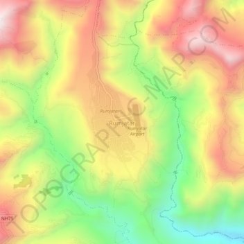
Name: Rumjatar topographic map, elevation, terrain.

Location: Rumjatar, Siddhicharan, Okhaldhunga, Koshi Province, Nepal (27.28222 86.52834 27.32222 86.56834)

Average elevation: 1,263 m

Minimum elevation: 798 m

Maximum elevation: 1,701 m

Other topographic maps

Click on a map to view its topography, its elevation and its terrain.

Siddhicharan

Nepal > Koshi Province > Okhaldhunga

Average elevation: 1,659 m

Manebhanjyang

Nepal > Koshi Province > Okhaldhunga

Average elevation: 1,066 m

Manebhanjyang

Nepal > Koshi Province > Okhaldhunga

Average elevation: 1,066 m

Gear up for your next adventure:

🧭GPS Outdoor Watch - Smart watch for navigation and fitness tracking in nature
🕶️Polarized Sunglasses - Protect your eyes with durable polarized lenses
🥾Trail Hiking Shoes - Durable shoes designed for rugged trails
🦯Trekking Poles - Reduced impact on joints for steep topographic climbs
🥾Waterproof Hiking Boots - Essential footwear for rugged terrain and wet Canadian trails

As an Amazon Associate, this site earns from qualifying purchases at no extra cost to you.