Geolocate

Moresco topographic map

Click on the map to display elevation.

About this map

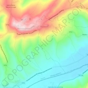
Name: Moresco topographic map, elevation, terrain.

Location: Moresco, Fermo, Marche, 63826, Italy (43.06615 13.72641 43.09033 13.77664)

Average elevation: 212 m

Minimum elevation: 63 m

Maximum elevation: 459 m

Other topographic maps

Click on a map to view its topography, its elevation and its terrain.

Monte Priora

Italy > Marche > Fermo > Montefortino

Average elevation: 1,808 m

Coriconi

Italy > Marche > Fermo > Amandola

Average elevation: 505 m

Gear up for your next adventure:

🦌Outdoor Trail Camera - Monitor wildlife activity near your favorite spots
Lightweight Camping Tent - Portable shelter optimized for Canadian backcountry camping
🥾Hiking Boots - Sturdy boots providing ankle support and traction on rugged trails
Family Camping Tent - Spacious tent suitable for family camping trips
🧼Travel Hand Sanitizer - Keep hands clean when water is scarce

As an Amazon Associate, this site earns from qualifying purchases at no extra cost to you.