Geolocate

Bérive topographic map

Click on the map to display elevation.

About this map

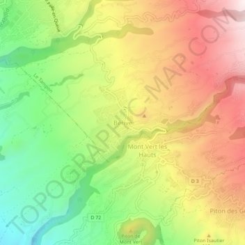
Name: Bérive topographic map, elevation, terrain.

Location: Bérive, Le Tampon, Saint-Pierre, La Réunion, 97430, France (-21.33014 55.51735 -21.29014 55.55735)

Average elevation: 576 m

Minimum elevation: 259 m

Maximum elevation: 905 m

Other topographic maps

Click on a map to view its topography, its elevation and its terrain.

Bras Creux

France > La Réunion > Le Tampon

Average elevation: 1,125 m

Bras Creux

France > La Réunion > Le Tampon

Average elevation: 1,414 m

Bois Court

France > La Réunion > Le Tampon

Average elevation: 1,186 m

Bras Creux

France > La Réunion > Le Tampon

Average elevation: 840 m

Gear up for your next adventure:

🥾Hiking Shoes - Durable and comfortable shoes for trail hiking
🎒Hiking Backpack - Lightweight and ergonomic backpacks for day hikes or multi-day treks
🛌Insulated Sleeping Pad - Critical thermal barrier between you and the cold ground
🕶️Polarized Sunglasses - Reduces glare from snow and water at high elevations
🚲Bike Repair Kit - Essential tools for on-trail mechanical issues

As an Amazon Associate, this site earns from qualifying purchases at no extra cost to you.