Geolocate

La Florida topographic map

Click on the map to display elevation.

About this map

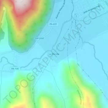
Name: La Florida topographic map, elevation, terrain.

Location: La Florida, Chontabamba, Oxapampa, Pasco, Perú (-10.61980 -75.43458 -10.57980 -75.39458)

Average elevation: 1,958 m

Minimum elevation: 1,795 m

Maximum elevation: 2,692 m

Other topographic maps

Click on a map to view its topography, its elevation and its terrain.

Gear up for your next adventure:

🥾Waterproof Hiking Boots - Boots keeping your feet dry in wet conditions
🚲Heavy Duty Bike Lock - Secure your bike at the trailhead or during stops
🧴Waterproofing Spray - Restore the DWR coating on jackets and tents
🔭Compact Monocular - One-handed bird watching and trail spotting
🔦LED Headlamp - Hands-free lighting for early morning starts or late finishes

As an Amazon Associate, this site earns from qualifying purchases at no extra cost to you.