
Make a donation
Gear up for your next adventure:
As an Amazon Associate, this site earns from qualifying purchases at no extra cost to you.
Needle Hill topographic map
Click on the map to display elevation.
Make a donation
Gear up for your next adventure:
As an Amazon Associate, this site earns from qualifying purchases at no extra cost to you.
Needle Hill
Needle Hill or Cham Shan (Chinese: 針山) is a mountain in New Territories, Hong Kong. It has an altitude of 532 m. This is a part of a popular hiking route including Grassy Hill and Tai Mo Shan. The mountain got its name due to the resemblance of a needle by its peak.
Make a donation
Gear up for your next adventure:
As an Amazon Associate, this site earns from qualifying purchases at no extra cost to you.
About this map
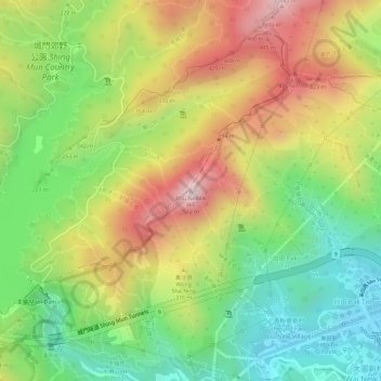
Name: Needle Hill topographic map, elevation, terrain.
Average elevation: 234 m
Minimum elevation: 7 m
Maximum elevation: 487 m
Make a donation
Gear up for your next adventure:
As an Amazon Associate, this site earns from qualifying purchases at no extra cost to you.
Other topographic maps
Click on a map to view its topography, its elevation and its terrain.
Wu Kai Sha Beach
China > Hong Kong > Sha Tin District > Wu Kai Sha Village > Cheung Kang Village
Average elevation: 36 m