
Make a donation
Gear up for your next adventure:
As an Amazon Associate, this site earns from qualifying purchases at no extra cost to you.
Col du Glandon topographic map
Click on the map to display elevation.
Make a donation
Gear up for your next adventure:
As an Amazon Associate, this site earns from qualifying purchases at no extra cost to you.
Col du Glandon
Le col du Glandon à 1 922 mètres d'altitude se situe entre la chaîne de Belledonne et le massif des Arves, trois kilomètres à l'ouest du col de la Croix-de-Fer. Il relie la vallée de la Romanche à celle de la Maurienne.
Make a donation
Gear up for your next adventure:
As an Amazon Associate, this site earns from qualifying purchases at no extra cost to you.
About this map
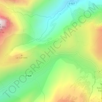
Name: Col du Glandon topographic map, elevation, terrain.
Average elevation: 1,939 m
Minimum elevation: 1,568 m
Maximum elevation: 2,486 m
Make a donation
Gear up for your next adventure:
As an Amazon Associate, this site earns from qualifying purchases at no extra cost to you.
Other topographic maps
Click on a map to view its topography, its elevation and its terrain.
Refuges de l'Oule ( Antoine Cros)
France > Auvergne-Rhône-Alpes > Savoie > Saint-Colomban-des-Villards
Average elevation: 2,068 m