
Make a donation
Gear up for your next adventure:
As an Amazon Associate, this site earns from qualifying purchases at no extra cost to you.
Somerset topographic map
Click on the map to display elevation.
Make a donation
Gear up for your next adventure:
As an Amazon Associate, this site earns from qualifying purchases at no extra cost to you.
Somerset
Somerset has the ninth-highest elevation of towns in Pennsylvania, at 2,190 feet (670 m) above sea level. Somerset County is in Appalachia.
Make a donation
Gear up for your next adventure:
As an Amazon Associate, this site earns from qualifying purchases at no extra cost to you.
About this map
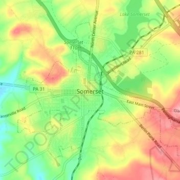
Name: Somerset topographic map, elevation, terrain.
Location: Somerset, Somerset County, Pennsylvania, United States (39.98958 -79.10472 40.02786 -79.03876)
Average elevation: 662 m
Minimum elevation: 608 m
Maximum elevation: 724 m
Make a donation
Gear up for your next adventure:
As an Amazon Associate, this site earns from qualifying purchases at no extra cost to you.
Other topographic maps
Click on a map to view its topography, its elevation and its terrain.
Hollsopple
United States > Pennsylvania > Somerset County > Conemaugh Township
Average elevation: 545 m
Kantner
United States > Pennsylvania > Somerset County > Quemahoning Township
Average elevation: 608 m
Ralphton
United States > Pennsylvania > Somerset County > Quemahoning Township > Ralphton
Average elevation: 636 m
Make a donation
Gear up for your next adventure:
As an Amazon Associate, this site earns from qualifying purchases at no extra cost to you.
Listie
United States > Pennsylvania > Somerset County > Somerset Township > Listie
Average elevation: 682 m
Boynton
United States > Pennsylvania > Somerset County > Elk Lick Township > Boynton
Average elevation: 656 m
Bearwallow Mountain
United States > Pennsylvania > Somerset County > Fairhope Township
Average elevation: 660 m