
Make a donation
Gear up for your next adventure:
As an Amazon Associate, this site earns from qualifying purchases at no extra cost to you.
Bohleysville topographic map
Click on the map to display elevation.
Make a donation
Gear up for your next adventure:
As an Amazon Associate, this site earns from qualifying purchases at no extra cost to you.
About this map
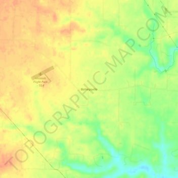
Name: Bohleysville topographic map, elevation, terrain.
Location: Bohleysville, Saint Clair County, Illinois, United States (38.39533 -90.13872 38.43533 -90.09872)
Average elevation: 186 m
Minimum elevation: 159 m
Maximum elevation: 202 m
Make a donation
Gear up for your next adventure:
As an Amazon Associate, this site earns from qualifying purchases at no extra cost to you.
Other topographic maps
Click on a map to view its topography, its elevation and its terrain.
Make a donation
Gear up for your next adventure:
As an Amazon Associate, this site earns from qualifying purchases at no extra cost to you.
Make a donation
Gear up for your next adventure:
As an Amazon Associate, this site earns from qualifying purchases at no extra cost to you.
Make a donation
Gear up for your next adventure:
As an Amazon Associate, this site earns from qualifying purchases at no extra cost to you.
Make a donation
Gear up for your next adventure:
As an Amazon Associate, this site earns from qualifying purchases at no extra cost to you.
Washington Park
United States > Illinois > Saint Clair County > Washington Park
Average elevation: 128 m
Make a donation
Gear up for your next adventure:
As an Amazon Associate, this site earns from qualifying purchases at no extra cost to you.
Cahokia Mounds State Historic Site
United States > Illinois > Saint Clair County > Fairmont City
To the south of Monks Mound is the Grand Plaza, a large area that covered roughly 50 acres (20 ha) and measured over 1,600 ft (490 m) in length by over 900 ft (270 m) in width. Researchers originally thought the flat, open terrain in this area reflected Cahokia's location on the Mississippi's alluvial flood…
Average elevation: 128 m
East Carondelet
United States > Illinois > Saint Clair County > East Carondelet
Average elevation: 123 m