Geolocate

Nepean Bay topographic map

Click on the map to display elevation.

About this map

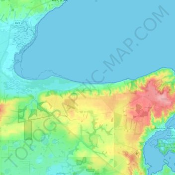
Name: Nepean Bay topographic map, elevation, terrain.

Location: Nepean Bay, Kangaroo Island Council, South Australia, 5223, Australia (-35.76912 137.56045 -35.71823 137.78475)

Average elevation: 25 m

Minimum elevation: -1 m

Maximum elevation: 123 m

Other topographic maps

Click on a map to view its topography, its elevation and its terrain.

Gear up for your next adventure:

Family Camping Tent - Spacious tent suitable for family camping trips
🥾Trail Hiking Shoes - Durable shoes designed for rugged trails
🧣Merino Neck Gaiter - Protects against wind, sun, and cold at high altitudes
🧥Fleece Jacket - Warm and lightweight jacket for layering
🧣Evaporative Cooling Towel - Beat the heat during intense summer climbs

As an Amazon Associate, this site earns from qualifying purchases at no extra cost to you.