Geolocate

Bergkirchen topographic map

Click on the map to display elevation.

About this map

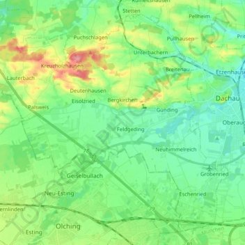
Name: Bergkirchen topographic map, elevation, terrain.

Location: Bergkirchen, Landkreis Dachau, Bavaria, 85232, Germany (48.20114 11.27644 48.29599 11.43617)

Average elevation: 502 m

Minimum elevation: 474 m

Maximum elevation: 570 m

Other topographic maps

Click on a map to view its topography, its elevation and its terrain.

Pellheim

Germany > Bavaria > Landkreis Dachau > Dachau

Average elevation: 503 m

Webling

Germany > Bavaria > Landkreis Dachau > Dachau

Average elevation: 495 m

Eisenhofen

Germany > Bavaria > Landkreis Dachau

Average elevation: 493 m

Gear up for your next adventure:

🥾Hiking Shoes - Durable and comfortable shoes for trail hiking
🧭GPS Handheld Device - Reliable GPS navigation for outdoor adventures
🛶Canoe Life Vest - Safety vest for water sports
🛏️Camping Sleeping Mat - Comfortable mats for sleeping outdoors
🥾Mountain Trail Shoes - High-traction shoes for mountain trails

As an Amazon Associate, this site earns from qualifying purchases at no extra cost to you.