Geolocate

El Paredon topographic map

Click on the map to display elevation.

About this map

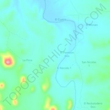
Name: El Paredon topographic map, elevation, terrain.

Location: El Paredon, Hermosillo, Sonora, Mexico (29.17200 -110.62700 29.21200 -110.58700)

Average elevation: 337 m

Minimum elevation: 305 m

Maximum elevation: 491 m

Gear up for your next adventure:

🚲MTB Frame Bag - Carry tools and maps directly on your bicycle frame
👟Leg Gaiters - Keep debris, mud, and snow out of your boots
🧭GPS Tracker - Track your location in remote areas safely
🛶Waterproof Dry Bags - Keep electronics and clothes dry during river crossings
🧢Outdoor Visor - Breathable visor for sunny hikes

As an Amazon Associate, this site earns from qualifying purchases at no extra cost to you.