Geolocate

Kugti topographic map

Click on the map to display elevation.

About this map

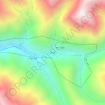
Name: Kugti topographic map, elevation, terrain.

Location: Kugti, Brahmaur, Chamba, Himachal Pradesh, India (32.44984 76.68454 32.48984 76.72454)

Average elevation: 3,104 m

Minimum elevation: 2,440 m

Maximum elevation: 4,007 m

Other topographic maps

Click on a map to view its topography, its elevation and its terrain.

Gauri Kund

India > Himachal Pradesh > Brahmaur

Average elevation: 4,185 m

Hadsar

India > Himachal Pradesh > Brahmaur

Average elevation: 2,401 m

Bharmour

India > Himachal Pradesh > Brahmaur

Average elevation: 2,204 m

Gear up for your next adventure:

🥾Light Hiking Boots - Lightweight and comfortable boots for day hikes
🥾All-Terrain Hiking Boots - Versatile boots for varied hiking conditions
🥾Lightweight Hiking Boots - Boots for comfort and mobility on long hikes
Bushcraft Tarp - Versatile emergency shelter or gear protection
🥾Trail Running Shoes - Lightweight and durable shoes for trail running

As an Amazon Associate, this site earns from qualifying purchases at no extra cost to you.