
Santa Cruz topographic map
Interactive map
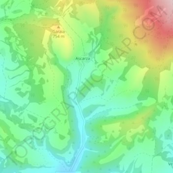
Click on the map to display elevation.
About this map
Name: Santa Cruz topographic map, elevation, terrain.
Average elevation: 670 m
Minimum elevation: 575 m
Maximum elevation: 852 m
Other topographic maps
Click on a map to view its topography, its elevation and its terrain.
La Sierra
Spain > Castile and León > Condado de Treviño
La Sierra, Condado de Treviño, Burgos, Castile and León, Spain
Average elevation: 886 m
La Sierra
Spain > Castile and León > Condado de Treviño
La Sierra, Condado de Treviño, Ebro, Burgos, Castile and León, Spain
Average elevation: 790 m
San Juan
Spain > Castile and León > Condado de Treviño
San Juan, Condado de Treviño, Ebro, Burgos, Castile and León, Spain
Average elevation: 649 m
Atua
Spain > Castile and León > Condado de Treviño
Atua, Condado de Treviño, Ebro, Burgos, Castile and León, Spain
Average elevation: 629 m