
Make a donation
Gear up for your next adventure:
As an Amazon Associate, this site earns from qualifying purchases at no extra cost to you.
IEL Gomia topographic map
Click on the map to display elevation.
Make a donation
Gear up for your next adventure:
As an Amazon Associate, this site earns from qualifying purchases at no extra cost to you.
IEL Gomia
Gumia is located at 23°48′38″N 85°49′24″E / 23.8106°N 85.8232°E / 23.8106; 85.8232. It has an average elevation of 238 metres (780 feet) and lies within the deciduous forests of Chota Nagpur Plateau
Make a donation
Gear up for your next adventure:
As an Amazon Associate, this site earns from qualifying purchases at no extra cost to you.
About this map
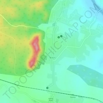
Name: IEL Gomia topographic map, elevation, terrain.
Location: IEL Gomia, Gumia, Bokaro, Jharkhand, 829112, India (23.80389 85.81410 23.82389 85.83410)
Average elevation: 279 m
Minimum elevation: 234 m
Maximum elevation: 375 m
Make a donation
Gear up for your next adventure:
As an Amazon Associate, this site earns from qualifying purchases at no extra cost to you.