Geolocate

Pataz topographic map

Click on the map to display elevation.

About this map

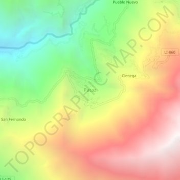
Name: Pataz topographic map, elevation, terrain.

Location: Pataz, Patáz, Pataz, La Libertad, Perú (-7.80612 -77.61341 -7.76612 -77.57341)

Average elevation: 2,905 m

Minimum elevation: 1,742 m

Maximum elevation: 4,110 m

Other topographic maps

Click on a map to view its topography, its elevation and its terrain.

Patáz

Perú > La Libertad > Patáz

Average elevation: 2,988 m

Gear up for your next adventure:

🥾Waterproof Hiking Boots - Boots keeping your feet dry in wet conditions
🥾Trail Hiking Boots - Supportive boots for rough trails
🔦LED Headtorch - Bright and durable light for night activities
🥾Waterproof Hiking Shoes - Durable shoes for wet and rugged trails
🚑Survival Whistle - Signal for help across long distances in mountains

As an Amazon Associate, this site earns from qualifying purchases at no extra cost to you.