Geolocate

Fairway topographic map

Click on the map to display elevation.

About this map

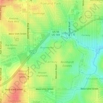
Name: Fairway topographic map, elevation, terrain.

Location: Fairway, Johnson County, Kansas, United States (39.01509 -94.63977 39.03463 -94.61582)

Average elevation: 290 m

Minimum elevation: 263 m

Maximum elevation: 317 m

Other topographic maps

Click on a map to view its topography, its elevation and its terrain.

Zarah

United States > Kansas > Johnson County > Shawnee

Average elevation: 268 m

Gear up for your next adventure:

🩹Moleskin Blister Pads - Direct protection for painful foot pressure points
🧥Thermal Fleece Jacket - Versatile insulation for changing mountain temperatures
🧥Waterproof Hiking Jacket - Protect yourself from rain and wind while hiking
Lightweight Backpacking Tent - Compact tent for efficient hiking trips
Tent Footprint - Protect tent floor and increase durability

As an Amazon Associate, this site earns from qualifying purchases at no extra cost to you.