Geolocate

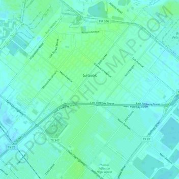
Groves topographic map

Click on the map to display elevation.

Groves

According to the United States Census Bureau, the city of Groves has a total area of 5.2 square miles (13.4 km2), of which 0.015 square miles (0.04 km2), or 0.28%, are water. Most of the city sits at an elevation of 5 to 15 feet (1.5 to 4.6 m) above sea level.

Wikipedia (CC-BY-SA 3.0)

About this map

Name: Groves topographic map, elevation, terrain.

Location: Groves, Jefferson County, Texas, 77619, United States (29.92488 -93.94477 29.96423 -93.89173)

Average elevation: 4 m

Minimum elevation: -2 m

Maximum elevation: 9 m

Other topographic maps

Click on a map to view its topography, its elevation and its terrain.

Hamshire

United States > Texas > Jefferson County

Average elevation: 6 m

Beaumont

United States > Texas > Jefferson County > Beaumont

Average elevation: 6 m

Zummo

United States > Texas > Jefferson County > Beaumont

Average elevation: 6 m

Gear up for your next adventure:

🐕Hiking Dog Pack - Let your canine companion carry their own water and food
🔦LED Headtorch - Bright and durable light for night activities
🥾Mountain Hiking Boots - High-traction boots for rocky terrain
🕶️Polarized Sunglasses - Reduces glare from snow and water at high elevations
🔭Compact Binoculars - Lightweight optics for scouting trails and wildlife

As an Amazon Associate, this site earns from qualifying purchases at no extra cost to you.