
Andenhausen topographic map
Interactive map
Click on the map to display elevation.
About this map
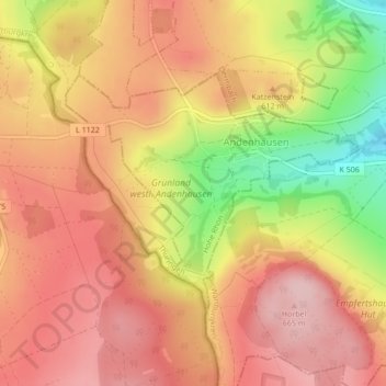
Name: Andenhausen topographic map, elevation, terrain.
Average elevation: 595 m
Minimum elevation: 469 m
Maximum elevation: 666 m
Other topographic maps
Click on a map to view its topography, its elevation and its terrain.
Aschenhausen
Deutschland > Thüringen > Kaltennordheim
Aschenhausen, Kaltennordheim, Hohe Rhön, Landkreis Schmalkalden-Meiningen, Thüringen, Deutschland
Average elevation: 538 m
Kaltenwestheim
Deutschland > Thüringen > Kaltennordheim
Kaltenwestheim, Kaltennordheim, Hohe Rhön, Landkreis Schmalkalden-Meiningen, Thüringen, Deutschland
Average elevation: 565 m