Geolocate

Binoni topographic map

Click on the map to display elevation.

About this map

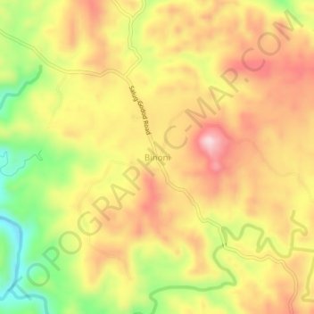
Name: Binoni topographic map, elevation, terrain.

Location: Binoni, Zamboanga del Norte, Zamboanga Peninsula, Philippines (8.04644 122.78234 8.08644 122.82234)

Average elevation: 212 m

Minimum elevation: 47 m

Maximum elevation: 339 m

Other topographic maps

Click on a map to view its topography, its elevation and its terrain.

Sibuco

Philippines > Zamboanga del Norte

Average elevation: 177 m

Dapitan River

Philippines > Zamboanga del Norte

Average elevation: 293 m

Sibuco

Philippines > Zamboanga del Norte

Average elevation: 177 m

Gear up for your next adventure:

🧣Evaporative Cooling Towel - Beat the heat during intense summer climbs
🥾Trail Hiking Boots - Supportive boots for rough trails
❄️Traction Ice Cleats - Slip-on spikes for icy trails and winter hiking
🏕️Camping Hammock - Integrated protection for sleeping between trees
🧴Waterproofing Spray - Restore the DWR coating on jackets and tents

As an Amazon Associate, this site earns from qualifying purchases at no extra cost to you.