Geolocate

Tenjo topographic map

Click on the map to display elevation.

About this map

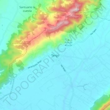
Name: Tenjo topographic map, elevation, terrain.

Location: Tenjo, Sabana Centro, RAP (Especial) Central, 250207, Colombia (4.83200 -74.18497 4.91200 -74.10497)

Average elevation: 2,682 m

Minimum elevation: 2,552 m

Maximum elevation: 3,221 m

Gear up for your next adventure:

🛌Down Sleeping Bag - Superior warmth-to-weight ratio for cold nights
🥾Hiking Boots - Sturdy boots providing ankle support and traction on rugged trails
🥾Trail Hiking Boots - Supportive boots for rough trails
🍽️Titanium Camping Spork - Ultralight and indestructible eating utensil
🥾Waterproof Trail Shoes - Shoes designed to handle wet terrain

As an Amazon Associate, this site earns from qualifying purchases at no extra cost to you.