Geolocate

Tatopani topographic map

Click on the map to display elevation.

About this map

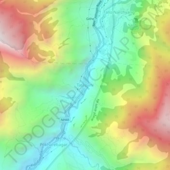
Name: Tatopani topographic map, elevation, terrain.

Location: Tatopani, Annapurna, Myagdi, Gandaki Province, Nepal (28.47758 83.63396 28.51758 83.67396)

Average elevation: 1,826 m

Minimum elevation: 1,153 m

Maximum elevation: 2,855 m

Other topographic maps

Click on a map to view its topography, its elevation and its terrain.

Malika

Nepal > Gandaki Province > Myagdi

Average elevation: 2,161 m

Mangala

Nepal > Gandaki Province > Myagdi

Average elevation: 1,912 m

Mangala

Nepal > Gandaki Province > Myagdi

Average elevation: 1,912 m

Gear up for your next adventure:

🩹Moleskin Blister Pads - Direct protection for painful foot pressure points
Family Camping Tent - Spacious tent suitable for family camping trips
🧰Survival Kit - Essential gear for emergencies in the wilderness
🏃Hydration Running Vest - Carry water and maps close to your body for speed
🧥Ultralight Puffy Jacket - Maximum warmth that packs down to the size of an orange

As an Amazon Associate, this site earns from qualifying purchases at no extra cost to you.