Geolocate

Giannutri topographic map

Click on the map to display elevation.

About this map

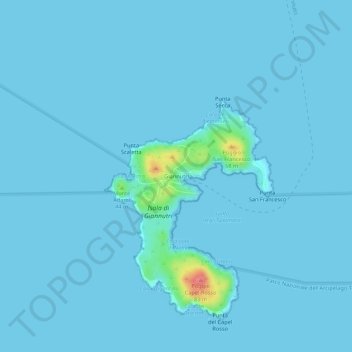
Name: Giannutri topographic map, elevation, terrain.

Location: Giannutri, Isola del Giglio, Grosseto, Tuscany, Italy (42.23438 11.08261 42.27438 11.12261)

Average elevation: 3 m

Minimum elevation: 0 m

Maximum elevation: 82 m

Other topographic maps

Click on a map to view its topography, its elevation and its terrain.

Isola del Giglio

Italy > Tuscany > Grosseto > Giglio Castello

Average elevation: 57 m

Gear up for your next adventure:

Family Camping Tent - Spacious tent suitable for family camping trips
🧭GPS Outdoor Watch - Smart watch for navigation and fitness tracking in nature
🧴Waterproofing Spray - Restore the DWR coating on jackets and tents
💧Filtered Water Bottle - Safe drinking water on the go
🧥Softshell Jacket - Windproof and breathable jacket for hiking

As an Amazon Associate, this site earns from qualifying purchases at no extra cost to you.