
Make a donation
Gear up for your next adventure:
As an Amazon Associate, this site earns from qualifying purchases at no extra cost to you.
Anawangin Cove topographic map
Click on the map to display elevation.
Make a donation
Gear up for your next adventure:
As an Amazon Associate, this site earns from qualifying purchases at no extra cost to you.
About this map
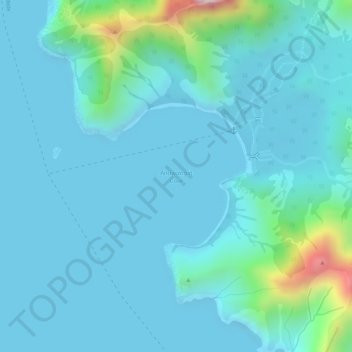
Name: Anawangin Cove topographic map, elevation, terrain.
Location: Anawangin Cove, Zambales, Central Luzon, Philippines (14.87112 120.05793 14.88188 120.07093)
Average elevation: 60 m
Minimum elevation: 0 m
Maximum elevation: 444 m
Make a donation
Gear up for your next adventure:
As an Amazon Associate, this site earns from qualifying purchases at no extra cost to you.
Other topographic maps
Click on a map to view its topography, its elevation and its terrain.
Make a donation
Gear up for your next adventure:
As an Amazon Associate, this site earns from qualifying purchases at no extra cost to you.
San Marcelino
In 1843, the Marcelinians filed a petition for San Marcelino's elevation to Pueblo through the Teniente Primero, Antonio Ladrido Juliano. In 1846, the petition was approved.
Average elevation: 45 m
Make a donation
Gear up for your next adventure:
As an Amazon Associate, this site earns from qualifying purchases at no extra cost to you.