Geolocate

Storumans kommun topographic map

Click on the map to display elevation.

About this map

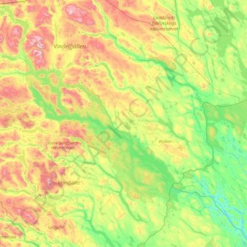
Name: Storumans kommun topographic map, elevation, terrain.

Location: Storumans kommun, Västerbotten County, Sweden (64.73314 14.49877 66.15000 17.95721)

Average elevation: 588 m

Minimum elevation: 250 m

Maximum elevation: 1,733 m

Gear up for your next adventure:

🥾Lightweight Hiking Boots - Boots for comfort and mobility on long hikes
🧰Emergency Multi-Tool - Compact multi-tool for outdoor survival
🧰Multitool Knife - Compact and versatile tool for outdoor use
🛏️Camping Sleeping Mat - Comfortable mats for sleeping outdoors
🔥Emergency Fire Starter - Reliable ignition source for all weather conditions

As an Amazon Associate, this site earns from qualifying purchases at no extra cost to you.