
Make a donation
Gear up for your next adventure:
As an Amazon Associate, this site earns from qualifying purchases at no extra cost to you.
KwaBhaca (Mount Frere) topographic map
Click on the map to display elevation.
Make a donation
Gear up for your next adventure:
As an Amazon Associate, this site earns from qualifying purchases at no extra cost to you.
About this map
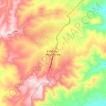
Name: KwaBhaca (Mount Frere) topographic map, elevation, terrain.
Average elevation: 1,116 m
Minimum elevation: 841 m
Maximum elevation: 1,320 m
Make a donation
Gear up for your next adventure:
As an Amazon Associate, this site earns from qualifying purchases at no extra cost to you.
Other topographic maps
Click on a map to view its topography, its elevation and its terrain.
Mzimvubu
South Africa > Eastern Cape > Alfred Nzo District Municipality > Umzimvubu Local Municipality
Average elevation: 1,041 m
Ntenetyana Dam
South Africa > Eastern Cape > Alfred Nzo District Municipality > Umzimvubu Local Municipality
Average elevation: 1,272 m
Qwidlana
South Africa > Eastern Cape > Alfred Nzo District Municipality > Umzimvubu Local Municipality
Average elevation: 1,190 m