
Make a donation
Gear up for your next adventure:
As an Amazon Associate, this site earns from qualifying purchases at no extra cost to you.
Sylhet topographic map
Click on the map to display elevation.
Make a donation
Gear up for your next adventure:
As an Amazon Associate, this site earns from qualifying purchases at no extra cost to you.
Sylhet
Sylhet is located at 24°53′30″N 91°53′00″E / 24.8917°N 91.8833°E / 24.8917; 91.8833, in the northeastern region of Bangladesh within the Sylhet Division, the Sylhet District and Sylhet Sadar Upazila. Sylhet has a typical Bangladeshi tropical monsoon climate (Köppen Am) bordering on a humid subtropical climate (Cwa) at higher elevations. The rainy season starts from April to October and it is so hot and humid with very heavy showers and thunderstorms almost every day, whilst the short dry season starts from November to February and it is very warm and fairly clear. Nearly 80% of the annual average rainfall of 4,200 millimetres (170 in) occurs between May and September.
Make a donation
Gear up for your next adventure:
As an Amazon Associate, this site earns from qualifying purchases at no extra cost to you.
About this map
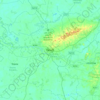
Name: Sylhet topographic map, elevation, terrain.
Average elevation: 14 m
Minimum elevation: 4 m
Maximum elevation: 66 m
Make a donation
Gear up for your next adventure:
As an Amazon Associate, this site earns from qualifying purchases at no extra cost to you.