Geolocate

Rauhenebrach topographic map

Click on the map to display elevation.

Rauhenebrach

mit einem BHU (Brusthöhenumfang) von 7,20 m. ⊙49.87613110.593019

Wikipedia (CC-BY-SA 3.0)

About this map

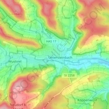
Name: Rauhenebrach topographic map, elevation, terrain.

Location: Rauhenebrach, Landkreis Haßberge, Bayern, 96181, Deutschland (49.86965 10.52932 49.90965 10.56932)

Average elevation: 360 m

Minimum elevation: 296 m

Maximum elevation: 439 m

Gear up for your next adventure:

🏕️Camping Hammock - Integrated protection for sleeping between trees
❄️Traction Ice Cleats - Slip-on spikes for icy trails and winter hiking
🧥Insulated Jacket - Keep warm in cold outdoor conditions
🪑Insulated Seat Pad - Protect your seat from cold rocks and wet logs
🔦LED Headtorch - Bright and durable light for night activities

As an Amazon Associate, this site earns from qualifying purchases at no extra cost to you.