
Thank you for supporting this site ❤️
Make a donation
Make a donation
Gear up for your next adventure:
As an Amazon Associate, this site earns from qualifying purchases at no extra cost to you.
Setiaasih topographic map
Click on the map to display elevation.
Thank you for supporting this site ❤️
Make a donation
Make a donation
Gear up for your next adventure:
As an Amazon Associate, this site earns from qualifying purchases at no extra cost to you.
About this map
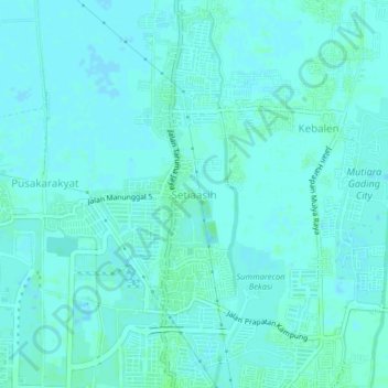
Name: Setiaasih topographic map, elevation, terrain.
Location: Setiaasih, Bekasi, West Java, Java, 17215, Indonesia (-6.16834 106.97323 -6.12834 107.01323)
Average elevation: 2 m
Minimum elevation: -1 m
Maximum elevation: 6 m
Thank you for supporting this site ❤️
Make a donation
Make a donation
Gear up for your next adventure:
As an Amazon Associate, this site earns from qualifying purchases at no extra cost to you.
Other topographic maps
Click on a map to view its topography, its elevation and its terrain.
Hutan Kota Patriot Bina Bangsa Kota Bekasi
Indonesia > West Java > Bekasi > Kayuringinjaya
Average elevation: 19 m