Geolocate

Molinete topographic map

Click on the map to display elevation.

About this map

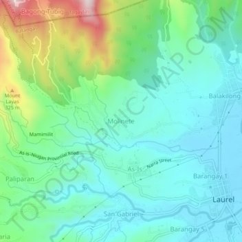
Name: Molinete topographic map, elevation, terrain.

Location: Molinete, Laurel, Batangas, Calabarzon, 4221, Philippines (14.04342 120.89573 14.08342 120.93573)

Average elevation: 122 m

Minimum elevation: 5 m

Maximum elevation: 477 m

Gear up for your next adventure:

🚲MTB Frame Bag - Carry tools and maps directly on your bicycle frame
🧭GPS Tracker - Track your location in remote areas safely
🎒Hiking Daypack - Lightweight and durable backpacks for day trips and excursions
📷Outdoor Action Camera - Capture high-elevation views and rugged adventures
🥤Collapsible Travel Cup - Saves space and weight in your mess kit

As an Amazon Associate, this site earns from qualifying purchases at no extra cost to you.