Geolocate

09432 topographic map

Click on the map to display elevation.

About this map

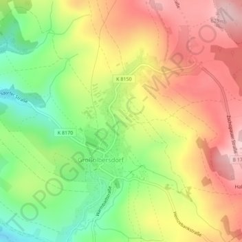
Name: 09432 topographic map, elevation, terrain.

Location: 09432, Großolbersdorf, Erzgebirgskreis, Sachsen, Deutschland (50.69782 13.09179 50.69792 13.09189)

Average elevation: 530 m

Minimum elevation: 417 m

Maximum elevation: 635 m

Gear up for your next adventure:

🔭Compact Monocular - One-handed bird watching and trail spotting
🧰Emergency Multi-Tool - Compact multi-tool for outdoor survival
🧥Insulated Jacket - Keep warm in cold outdoor conditions
🚲Handlebar Phone Mount - View topographic-map.com live while cycling
🥾Hiking Boots - Sturdy boots providing ankle support and traction on rugged trails

As an Amazon Associate, this site earns from qualifying purchases at no extra cost to you.