Geolocate

Báguena topographic map

Interactive map

Click on the map to display elevation.

About this map

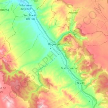
Name: Báguena topographic map, elevation, terrain.

Location: Báguena, Jiloca, Teruel, Aragon, Spain (40.99639 -1.41797 41.06568 -1.28302)

Average elevation: 938 m

Minimum elevation: 763 m

Maximum elevation: 1,147 m

Other topographic maps

Click on a map to view its topography, its elevation and its terrain.

Nogueras

Spain > Aragon > Jiloca

Nogueras, Jiloca, Teruel, Aragon, Spain

Average elevation: 915 m

Odón

Spain > Aragon > Jiloca

Odón, Jiloca, Teruel, Aragon, 50373, Spain

Average elevation: 1,108 m