Geolocate

Nederland topographic map

Click on the map to display elevation.

About this map

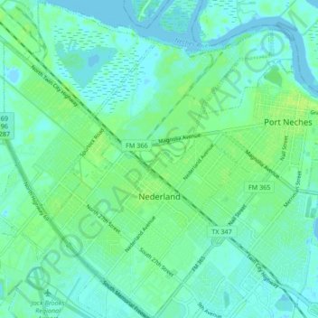
Name: Nederland topographic map, elevation, terrain.

Location: Nederland, Jefferson County, Texas, 77627, United States (29.94657 -94.04195 30.01903 -93.96296)

Average elevation: 4 m

Minimum elevation: -3 m

Maximum elevation: 10 m

Other topographic maps

Click on a map to view its topography, its elevation and its terrain.

Beaumont

United States > Texas > Jefferson County > Beaumont

Average elevation: 6 m

Gear up for your next adventure:

❄️Traction Ice Cleats - Slip-on spikes for icy trails and winter hiking
🧥Thermal Layer - Insulating layer for cold outdoor conditions
🧭Orienteering Kit - Tools for map reading and navigation in the wild
🚲Bike Repair Kit - Essential tools for on-trail mechanical issues
🧢Sun Protection Cap - Breathable cap to protect from sun exposure

As an Amazon Associate, this site earns from qualifying purchases at no extra cost to you.