
Thank you for supporting this site ❤️
Make a donation
Make a donation
Gear up for your next adventure:
As an Amazon Associate, this site earns from qualifying purchases at no extra cost to you.
Banyo topographic map
Click on the map to display elevation.
Thank you for supporting this site ❤️
Make a donation
Make a donation
Gear up for your next adventure:
As an Amazon Associate, this site earns from qualifying purchases at no extra cost to you.
About this map
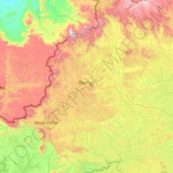
Name: Banyo topographic map, elevation, terrain.
Location: Banyo, Mayo-Banyo, Adamawa, Cameroon (6.19310 11.54656 7.25715 12.20887)
Average elevation: 1,105 m
Minimum elevation: 360 m
Maximum elevation: 2,414 m
Thank you for supporting this site ❤️
Make a donation
Make a donation
Gear up for your next adventure:
As an Amazon Associate, this site earns from qualifying purchases at no extra cost to you.