
Thank you for supporting this site ❤️
Make a donation
Make a donation
Gear up for your next adventure:
As an Amazon Associate, this site earns from qualifying purchases at no extra cost to you.
Tinnen topographic map
Click on the map to display elevation.
Thank you for supporting this site ❤️
Make a donation
Make a donation
Gear up for your next adventure:
As an Amazon Associate, this site earns from qualifying purchases at no extra cost to you.
About this map
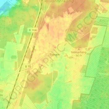
Name: Tinnen topographic map, elevation, terrain.
Average elevation: 27 m
Minimum elevation: 5 m
Maximum elevation: 38 m
Thank you for supporting this site ❤️
Make a donation
Make a donation
Gear up for your next adventure:
As an Amazon Associate, this site earns from qualifying purchases at no extra cost to you.
Other topographic maps
Click on a map to view its topography, its elevation and its terrain.
Schloss Dankern
Deutschland > Niedersachsen > Landkreis Emsland > Haren (Ems) > Altharen > Dankern
Average elevation: 12 m
Dankernsee
Deutschland > Niedersachsen > Landkreis Emsland > Haren (Ems) > Dankern
Average elevation: 13 m