Geolocate

Sparkford topographic map

Click on the map to display elevation.

About this map

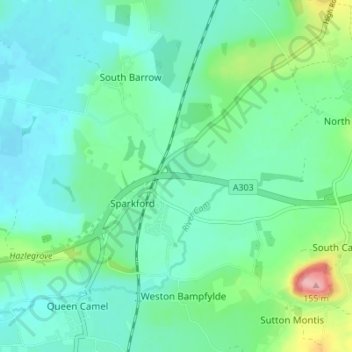
Name: Sparkford topographic map, elevation, terrain.

Location: Sparkford, Somerset, England, United Kingdom (51.01593 -2.57856 51.05912 -2.54046)

Average elevation: 48 m

Minimum elevation: 20 m

Maximum elevation: 149 m

Gear up for your next adventure:

🧤Insulated Winter Gloves - Heavy-duty protection for sub-zero Canadian adventures
🥾Light Trekking Boots - Supportive boots for multi-day treks
💡Portable Camping Lamp - Rechargeable lamp for campsite lighting
🧭GPS Tracker - Track your location in remote areas safely
🧳Compression Sacks - Maximize space in your backpack by shrinking gear

As an Amazon Associate, this site earns from qualifying purchases at no extra cost to you.