
Les Chattrix topographic map
Click on the map to display elevation.
About this map
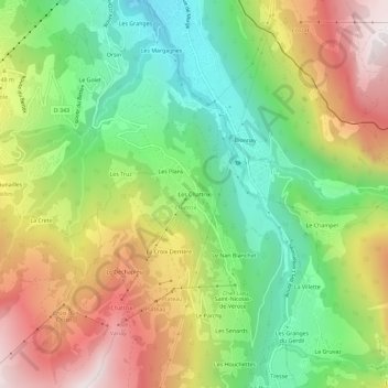
Name: Les Chattrix topographic map, elevation, terrain.
Average elevation: 1,269 m
Minimum elevation: 807 m
Maximum elevation: 1,868 m
Other topographic maps
Click on a map to view its topography, its elevation and its terrain.
Le Planet
France > Auvergne-Rhône-Alpes > Haute-Savoie > Saint-Gervais-les-Bains > Le Planet
Average elevation: 1,644 m
Glacier de Miage
France > Auvergne-Rhône-Alpes > Haute-Savoie > Saint-Gervais-les-Bains
Average elevation: 2,744 m
Bionnassay
France > Auvergne-Rhône-Alpes > Haute-Savoie > Saint-Gervais-les-Bains
Average elevation: 1,587 m
Lac glaciaire de Bionnassay
France > Auvergne-Rhône-Alpes > Haute-Savoie > Saint-Gervais-les-Bains
Average elevation: 1,993 m
Saint-Nicolas-de-Véroce
France > Auvergne-Rhône-Alpes > Haute-Savoie > Saint-Gervais-les-Bains
Average elevation: 1,559 m