Geolocate

Pokuru topographic map

Click on the map to display elevation.

About this map

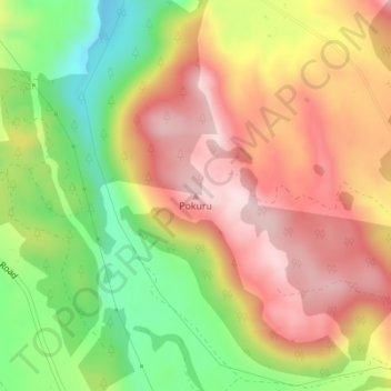
Name: Pokuru topographic map, elevation, terrain.

Location: Pokuru, Taupo District, Waikato, New Zealand (-38.48194 175.84789 -38.48184 175.84799)

Average elevation: 510 m

Minimum elevation: 328 m

Maximum elevation: 666 m

Other topographic maps

Click on a map to view its topography, its elevation and its terrain.

Hauhungaroa Range

New Zealand > Waikato > Taupo District

Average elevation: 753 m

Tongariro River

New Zealand > Waikato > Taupo District

Average elevation: 853 m

Lake Rotoaira

New Zealand > Waikato > Taupo District

Average elevation: 624 m

Lake Rotokawa

New Zealand > Waikato > Taupo District

Average elevation: 358 m

Lake Rotopounamu

New Zealand > Waikato > Taupo District

Average elevation: 784 m

Summit Plateau

New Zealand > Waikato > Taupo District

Average elevation: 2,454 m

Motutaiko Island

New Zealand > Waikato > Taupo District

Average elevation: 357 m

Gear up for your next adventure:

💧Filtered Water Bottle - Safe drinking water on the go
💡LED Camping Lantern - Illuminate your campsite with long-lasting lanterns
🦶Anti-Blister Balm - Prevents friction and hotspots during long ascents
👟Trail Running Shoes - Agile footwear for fast-paced topographic exploration
🥤Collapsible Travel Cup - Saves space and weight in your mess kit

As an Amazon Associate, this site earns from qualifying purchases at no extra cost to you.