
Make a donation
Gear up for your next adventure:
As an Amazon Associate, this site earns from qualifying purchases at no extra cost to you.
Beauvais-sur-Matha topographic map
Click on the map to display elevation.
Make a donation
Gear up for your next adventure:
As an Amazon Associate, this site earns from qualifying purchases at no extra cost to you.
Beauvais-sur-Matha
Perchée sur une colline de 135 mètres d’altitude, Beauvais doit son nom à sa situation géographique. L’origine du nom de la commune viendrait de Bellum Videre signifiant « belle vue », « belvédère », d’un ancien verbe écrit vedeir (voir) au XI siècle.
Make a donation
Gear up for your next adventure:
As an Amazon Associate, this site earns from qualifying purchases at no extra cost to you.
About this map
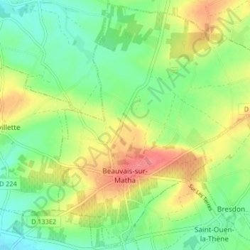
Name: Beauvais-sur-Matha topographic map, elevation, terrain.
Average elevation: 93 m
Minimum elevation: 62 m
Maximum elevation: 138 m
Make a donation
Gear up for your next adventure:
As an Amazon Associate, this site earns from qualifying purchases at no extra cost to you.
Other topographic maps
Click on a map to view its topography, its elevation and its terrain.
Make a donation
Gear up for your next adventure:
As an Amazon Associate, this site earns from qualifying purchases at no extra cost to you.
Barabe
France > Nouvelle-Aquitaine > Charente-Maritime > Chenac-Saint-Seurin-d'Uzet
Average elevation: 12 m
Saint-Seurin-d'Uzet
France > Nouvelle-Aquitaine > Charente-Maritime > Chenac-Saint-Seurin-d'Uzet
Average elevation: 14 m
Make a donation
Gear up for your next adventure:
As an Amazon Associate, this site earns from qualifying purchases at no extra cost to you.
Mauzac
France > Nouvelle-Aquitaine > Charente-Maritime > Saint-Just-Luzac > Luzac
Average elevation: 4 m
Make a donation
Gear up for your next adventure:
As an Amazon Associate, this site earns from qualifying purchases at no extra cost to you.
Chassiron
France > Nouvelle-Aquitaine > Charente-Maritime > Saint-Denis-d'Oléron
Average elevation: 2 m
Les Bris
France > Nouvelle-Aquitaine > Charente-Maritime > Saint-Trojan-les-Bains
Average elevation: 4 m
Make a donation
Gear up for your next adventure:
As an Amazon Associate, this site earns from qualifying purchases at no extra cost to you.
Saint-Denis-d'Oléron
France > Nouvelle-Aquitaine > Charente-Maritime > Saint-Denis-d'Oléron > Saint-Denis-d'Oléron
Average elevation: 3 m
Forêt du Douhet
France > Nouvelle-Aquitaine > Charente-Maritime > La Brée-les-Bains > Forêt du Douhet
Average elevation: 1 m