Geolocate

Midori Ward topographic map

Click on the map to display elevation.

About this map

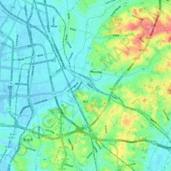
Name: Midori Ward topographic map, elevation, terrain.

Location: Midori Ward, Nagoya, Aichi Prefecture, Japan (35.03920 136.90579 35.10971 137.02354)

Average elevation: 20 m

Minimum elevation: -4 m

Maximum elevation: 79 m

Gear up for your next adventure:

🔭Compact Binoculars - Lightweight optics for scouting trails and wildlife
🔦LED Flashlight - Powerful and long-lasting flashlight for camping and emergencies
🧊Portable Cooler - Keep food and drinks cold during outdoor adventures
🧭Orienteering Kit - Tools for map reading and navigation in the wild
🥾Trail Running Shoes - Lightweight and durable shoes for trail running

As an Amazon Associate, this site earns from qualifying purchases at no extra cost to you.